Seine river map. Seine river map Paris

The Seine river maps show the Seine river 13 kilometer course through Paris and the 776 km Seine river course from its source in Burgundy through Paris into the English Channel. Locate cities along the Seine River. Locate top monuments on Paris Seine river monument map. Paris bridges map. Seine river walk maps. Seine river in Paris. Paris maps.
Seine river map in Paris
The Paris Seine river map locates the greatest sights of Paris along the banks of the Seine river. Many top sights are along the Seine river banks. The list of sights along the river includes the Eiffel Tower, the Musée d'Orsay, the Louvre, Notre-Dame Cathedral, Palais de Chaillot and 37 beautiful bridges. The Seine river flows 13 km through the city from South East to South West. The North bank is the Right Bank, la Rive Droite in French. The South bank is the Left Bank, la Rive Gauche in French. Relax and admire these beautiful sights on a Seine river cruise. More thematic Paris maps. Metro map.
Paris Seine river monument map
The top Paris monuments visible along the Seine River are represented on Seine river monument map. It includes Notre-Dame Cathedral, the Louvre Museum, the Eiffel Tower, Hotel de Ville (Paris City Hall), the Trocadéro (Palais de Chaillot), Musée d'Orsay and all bridges. Click on map to enlarge and print it.

Paris bridges map
The most famous bridges in Paris are the Pont Neuf, the oldest whose construction began in 1578, pedestrian Pont des Arts, Pont Alexandre III, built for the 1900 World's Fair and Pont d'Iena, in front of Eiffel Tower. Download detailed Paris Seine River bridge map.

Seine river walk maps
The Seine river left bank quays in between Musée d'Orsay, the impressionist museum, and the magnificent 1900 Pont Alexandre III have been turned into a very pleasant Seine river walk. Splendid views, open air restaurants and playgrounds are plenty. Rosa Bonheur and Flow, two open-air restaurants on these quays, are now the place to go to day and night. Most people enjoy picnicking, a cheaper option. Check Seine River left bank walk map.
The pedestrian right bank quays from Sully-Morland to the Louvre are famous picnicking spots. Check Seine River right bank walk map.

Rosa Bonheur is near Alexandre III bridge
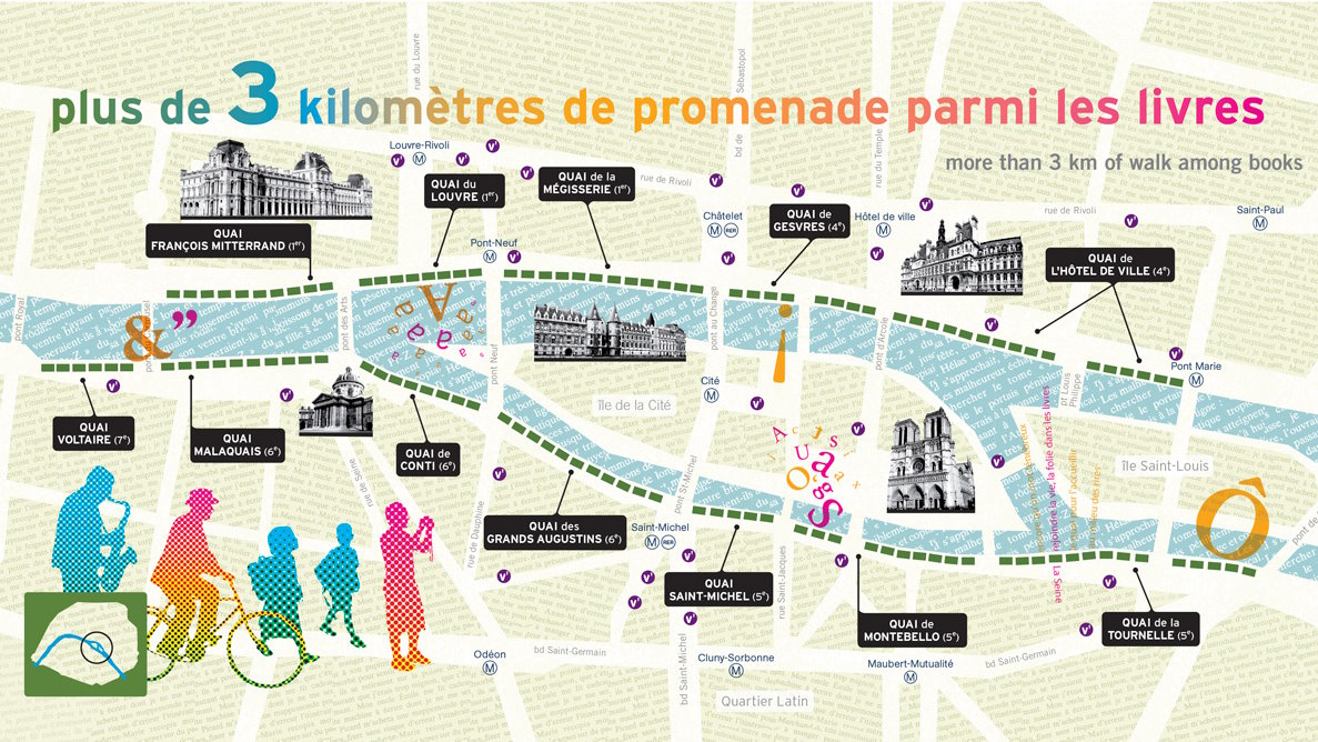
Seine river bookseller walk map
During the Universal Exhibition of 1900, there were already 200 booksellers on the banks of the Seine. Today, there are 3 kilometers of old or contemporary books, engravings, stamps and other magazines that we can explore. All installed on the parapets of the high quays on both banks of the Seine enclosing Ile de la Cité and Ile Saint-Louis.
While walking near the booksellers, admire the Louvre, the Institut de France, the Hôtel de la Monnaie, the Saint-Michel fountain, the Pont des Arts, the Île de la Cité, Notre-Dame Cathedral, the Hôtel de Ville, the Conciergerie and other monuments.
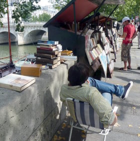
Booksellers invite you on the quays
Seine river cruise
The Seine river cruise is a top thing to do. In one hour, see the Eiffel Tower, Notre-Dame, Musée d'Orsay, the Louvre. With so many sights to see from the river, it is no wonder cruises are so appreciated as a first city discovery.
The Seine river lunch cruise is very appreciated as it combines good food and sightseeing. Book lunch cruise.
You want your Paris stay to be memorable. Go for the romantic dinner cruise or for the royal Seine night cruise with dinner at Eiffel Tower and Moulin Rouge cabaret. Book dinner cruise.
As a starter, you can do the classical one hour Seine cruise with Bateaux Parisiens or Vedettes du Ponf Neuf.
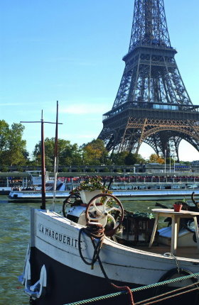 Paris cruises pass along the Eiffel Tower
Stay in top Paris hotel

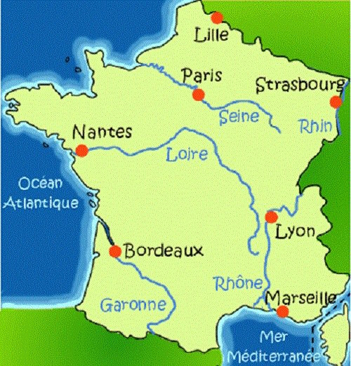
Seine river map France
The Seine river is a 776 kilometre long river flowing through Paris into the English Channel at Le Havre, Paris' harbor. Locate the Seine river on France river map. Its very calm course ends with numerous meanders.
The source to estuary Seine River map shows the Seine river, its main tributaries, the Yonne, Marne and Oise rivers, and the cities it flows throught, from its source to its estuary.
The Paris to the English Channel Seine river map shows the Seine river course from Paris to the sea. Paris, Rouen, Le Havre form now an integrated harbour. Giverny, Rouen, Honfleur and Deauville are top touristic sights in Normandy.

Cities along the Seine river
From its source to its estuary, the Seine river flows throught the cities of Chatillon-sur-Seine, Troyes, Melun, Paris, Conflans-Sainte-Honorine, Mantes, Vernon, Les Andelys, Rouen, Caudebec-en-Caux and Le Havre.
Seine river bike route maps
The Seine river estuary bike route map helps plan a bike tour on the best bike lanes in the Seine river estuary. Check the map with detailed information of "La Seine à Vélo", the new biking route along the Seine River from Paris to Le Havre.
Paris Olympics Seine River opening ceremony map
The Paris Olympics opening ceremony map shows the ceremony six kilometer course downtream on the Seine River, from Pont d'Austerlitz Bridge to Trocadéro. Notre-Dame Cathedral, Hotel de Ville, La Conciergerie, Place de la Concorde, the Louvre, the Pont Neuf, the Pont des Arts and the Eiffel Tower made up the iconic setting for this opening ceremony.

The top thematic Paris maps
Metro
As driving and parking are quite difficult in the city, the metro is the most heavily used means of transportation. The metro is safe and clean. Locate metro lines and metro stations on the map. Find your itinerary in town. Check our Paris metro map
Bus network
Download printable Paris bus network map.
Arrondissements
The city is divided into 20 arrondissements, its administrative subdivisions with each a separate city hall and a zip code. As example, the zip code of the 1st arrondissement is 75001. Locate most city top sights on the Paris Arrondissement map.
Hotels
There is a wide choice of hotels and apartments in town with very different quality and value for money. Most hotels are small and charming boutique hotels. Locate our favorite hotels in town and our favorite districts for hotels on Paris hotel map.
Restaurants
There is a huge number of restaurant in the city, both French and foreign. In general, the tourist districts offer poor value for money. But, there are exceptions. Locate our favorite restaurants in town on Paris restaurant map.
Shopping venues
From the huge shopping malls to the small specialized shops, there are shopping venues matching your taste. Locate the best shopping venues in the city on Paris shopping map: fashion streets, department stores, shopping malls, flea market.
Paris map pdf
It is quite practical to have and use a printed pdf map when in town. Check and print in town the free printable Paris map pdf with the main streets of the city, the metro stations, the train stations and the top tourist signts.
Monuments
Locate the top monuments on Paris monument map. It includes the Eiffel Tower, Notre-Dame, the Louvre, the Sacré-Coeur, the Arc de Triomphe, La Conciergerie, the Sainte Chapelle, the Fondation Louis Vuitton, Palais de Chaillot.
Museums
The city is world famous for its top museums of art: Musée d'Orsay, Louvre, Centre Pompidou, Musée d'Art Moderne, Musée Picasso, Musée Marmottan. Locate and view the top museums on Paris museum map.
Gardens and parks
Locate the top gardens and parks on Paris garden map: Luxembourg Gardens, Les Tuileries, Parc de la VIllette, Buttes-Chaumont, Parc Monceau, Bois de Boulogne, Bois de Vincennes.
Sightseeing
Locate and view the top sights on Paris sightseeing map: on one map, monuments, museums, parks and gardens.
Tourist map
Locate top tourist sights on Paris tourist map. It includes monuments, museums, gardens, shopping venues, restaurants